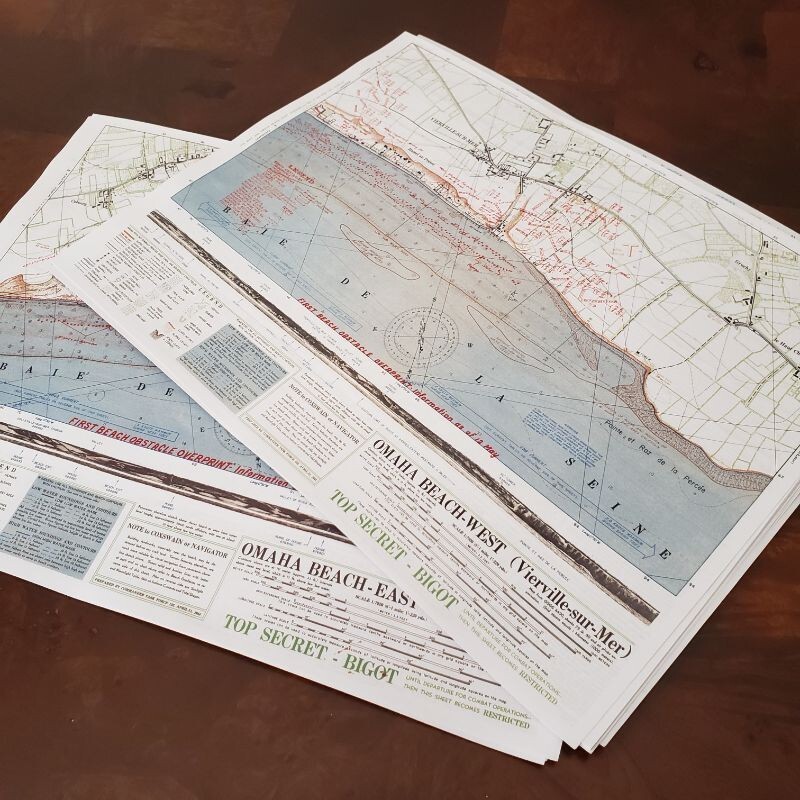
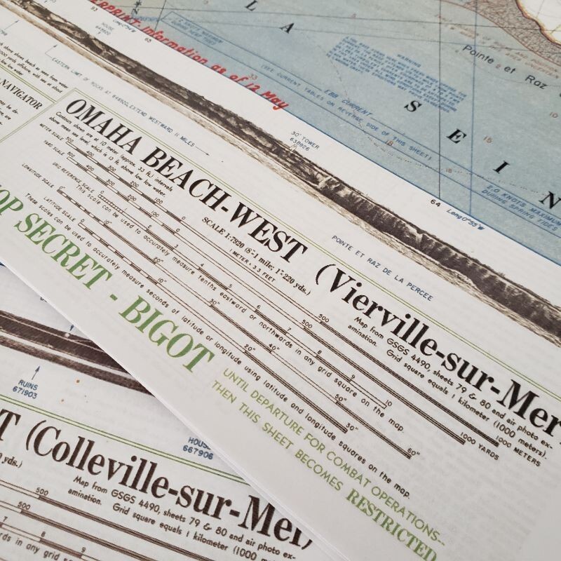
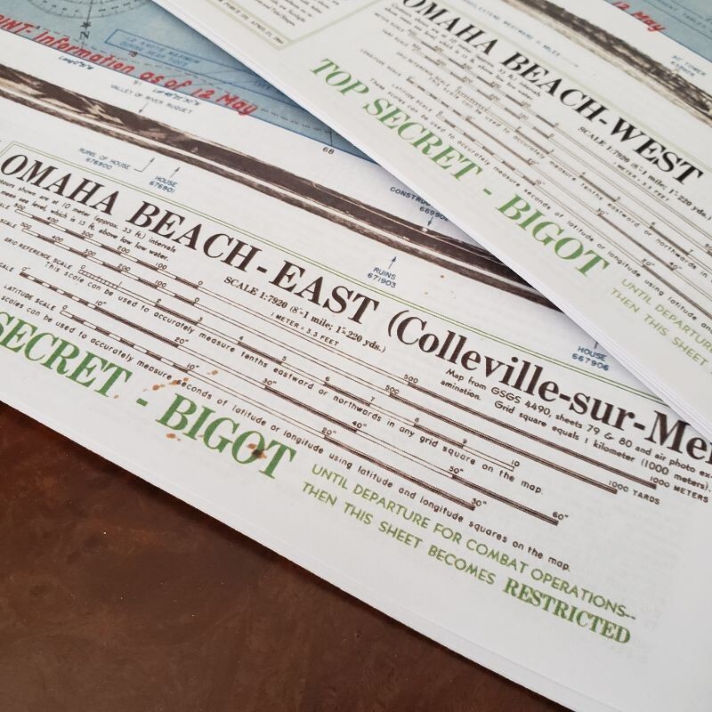
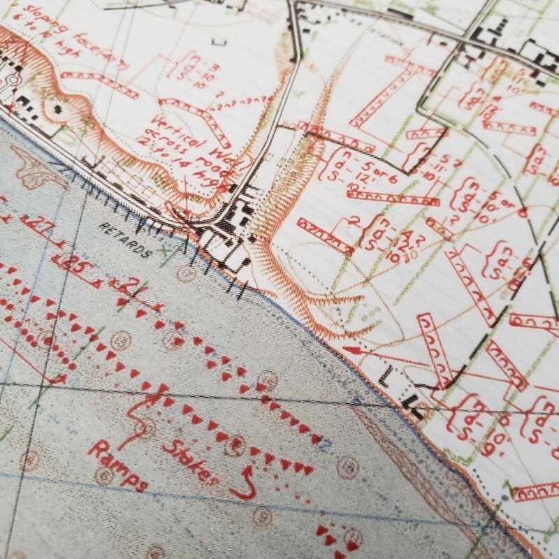
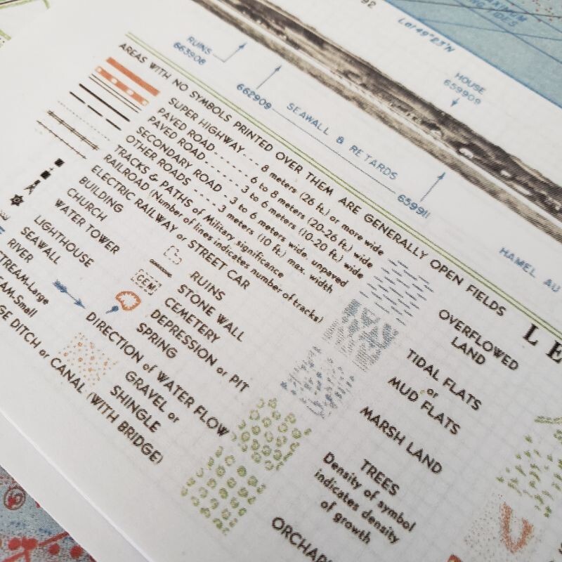
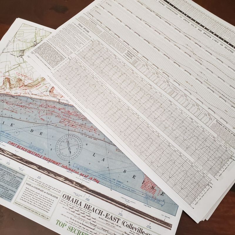
Amazing quality reproductions of two top secret invasion maps of Omaha Beach prior to D-Day. Very high resolution (1200dpi), both sides printed on thick glossy paper. Amazing display or reenacting prop piece! Maps depict:- East Omaha Beach (with navigation aiding graphs on reverse)- West Omaha Beach (with navigation aiding graphs on reverse)Last update of the maps was done on May 12, around 3wks prior to the landing. The maps are 11x14.5" (~57% of the original size). They will come to you folded in half. More about the maps:A rare and remarkable pair of Second World War planning maps depicting the Normandy coast at Colleville-sur-Mer and Vierville-sur-Mer, better known today simply as Omaha Beach. Issued less than a month before D-Day and bearing the ultra-secret “BIGOT” classification.“But nothing was more secret—or more vital to Operation Neptune—than the mosaic of Allied intelligence reports that cartographers and artists transformed into the multihued and multilayered BIGOT maps.” (Thomas B. Allen, “Untold Stories of D-Day,” National Geographic Magazine, June 2002, vol. 201, no. 6, p. 15)Of the five D-Day landing beaches, that of the American 1st and 29thInfantry Divisions at Omaha was by far the most harrowing. The beach was defended by the German 352nd Infantry Division—rather than a single regiment, as anticipated by Allied planners—which was well emplaced on high bluffs, with wide-open fields of fire overlooking the landing zone. Further complicating matters, many landing craft ran aground on sandbars, forcing infantrymen to wade through water up to their necks while heavily loaded and under fire; and most of the specialized amphibious tanks sent to support them were swamped before making it to the beach. As a result, the Americans were pinned to the beach for hours and suffered hugely, with casualty estimates ranging as high as 5000. Nevertheless, by mid-morning, they had breached the German defenses on the bluffs and begun moving inland.Offered here is a pair of maps - in essence, one continuous map on two sheets used by the American military to plan the Omaha Beach landings. Placed side by side, they offer a detailed picture of the Normandy coast between Colleville-sur-Mer and Vierville-sur-Mer. The base map is a familiar topographical map, with roads and built-up areas in black, green indicating different types of vegetation; and brown indicating elevations and topographical features, including the steep bluffs overlooking the beach. A variety of dashed lines in the water indicate depths at low (brown) and high (blue) tides.What makes these maps remarkable is the overprinting in red of the latest intelligence regarding beach obstacles, update to May 12, 1944. A bewildering variety of symbols are used to depict a range of obstacles, such as “hedgehogs” and “tetrahedrons,” designed to damage landing craft, or block tanks before they hit the beach. Others depict obstacles on land, including anti-tank ditches, roadblocks, and minefields. These last are shown in immense detail, including information about the numbers of rows of mines, the distance between rows, and the spacing of mines in each row. Below each map is a profile view of the coastline to facilitate navigation by the landing craft, with the practical note “Building landmarks, especially near the beach, may be destroyed before any craft land. Terrain features, therefore, are much more reliable for visual navigation.”Below the title of each map, a brief note hints at the complex, multi-layered information-gathering effort that yielded the BIGOT maps: “Map from GSGS 4490, sheets 79 & 80 and air photo examination.” Thus, the BIGOT maps were the product of a multilayered effort: Starting with existing base maps and hydrographic data, largely supplied by the British Hydrographic Office, military cartographers and artists added data from aerial reconnaissance surveys by Allied warplanes, including extraordinarily dangerous low-level overflights. To these were added information from a host of other sources, including reconnaissance of the beaches by commandos (“frogmen”) and reports from French Resistance fighters.The maps were issued in a variety of formats and frequently revised as new information became available. For example, the “Beach Obstacle Overprint” versions of the OMAHA BEACH-EAST and –WEST maps were reissued with updates to May 30.The BIGOT classificationBoth maps are prominently stamped in green, “TOP SECRET – BIGOT UNTIL DEPARTURE FOR COMBAT OPERATIONS—THEN THIS SHEET BECOMES RESTRICTED.” Introduced during the Second World War, BIGOT was the highest-level military security classification, above Top Secret. Some sources suggest that it was an acronym for “British Invasion of German Occupied Territory;” others, that it was a “backronym” for “To Gib,” the code stamped on the papers of officers headed to Gibraltar in advance of the 1942 North Africa invasion.Whatever the origins of the term, extraordinary efforts were made to protect BIGOT-level material. When for example a practice landing (“Operation Tiger”) on the Devon coast was ambushed by U-Boats, Eisenhower himself ordered the recovery of the bodies of the ten known victims with BIGOT clearance. This was necessary to prove that they had not been captured alive, as their capture would have compromised the invasion plans and necessitated its cancellation.Rarity and referencesA pair like that sold at Goldberg Auctions (sale 101, lot 142) for $13,800 in 2017.
| All Returns Accepted | ReturnsNotAccepted |
| Type | map |
| Conflict | WW II (1939-45) |
| Theme | Militaria |
| Original/Reproduction | Reproduction |
| Country/Region Of Manufacture | United States |
| Region Of Origin | United States |
Amazing quality reproductions of two top secret invasion maps of Omaha Beach prior to D-Day. Very high resolution (1200dpi), both sides printed on thick glossy paper. Amazing display or reenacting prop piece! Maps depict:- East Omaha Beach (with navigation aiding graphs on reverse)- West Omaha Beach (with navigation aiding graphs on reverse)Last update of the maps was done on May 12, around 3wks prior to the landing. The maps are 11×14.5″ (~57% of the original size). They will come to you folded in half. More about the maps:A rare and remarkable pair of Second World War planning maps depicting the Normandy coast at Colleville-sur-Mer and Vierville-sur-Mer, better known today simply as Omaha Beach. Issued less than a month before D-Day and bearing the ultra-secret “BIGOT” classification.“But nothing was more secret—or more vital to Operation Neptune—than the mosaic of Allied intelligence reports that cartographers and artists transformed into the multihued and multilayered BIGOT maps.” (Thomas B. Allen, “Untold Stories of D-Day,” National Geographic Magazine, June 2002, vol. 201, no. 6, p. 15)Of the five D-Day landing beaches, that of the American 1st and 29thInfantry Divisions at Omaha was by far the most harrowing. The beach was defended by the German 352nd Infantry Division—rather than a single regiment, as anticipated by Allied planners—which was well emplaced on high bluffs, with wide-open fields of fire overlooking the landing zone. Further complicating matters, many landing craft ran aground on sandbars, forcing infantrymen to wade through water up to their necks while heavily loaded and under fire; and most of the specialized amphibious tanks sent to support them were swamped before making it to the beach. As a result, the Americans were pinned to the beach for hours and suffered hugely, with casualty estimates ranging as high as 5000. Nevertheless, by mid-morning, they had breached the German defenses on the bluffs and begun moving inland.Offered here is a pair of maps – in essence, one continuous map on two sheets used by the American military to plan the Omaha Beach landings. Placed side by side, they offer a detailed picture of the Normandy coast between Colleville-sur-Mer and Vierville-sur-Mer. The base map is a familiar topographical map, with roads and built-up areas in black, green indicating different types of vegetation; and brown indicating elevations and topographical features, including the steep bluffs overlooking the beach. A variety of dashed lines in the water indicate depths at low (brown) and high (blue) tides.What makes these maps remarkable is the overprinting in red of the latest intelligence regarding beach obstacles, update to May 12, 1944. A bewildering variety of symbols are used to depict a range of obstacles, such as “hedgehogs” and “tetrahedrons,” designed to damage landing craft, or block tanks before they hit the beach. Others depict obstacles on land, including anti-tank ditches, roadblocks, and minefields. These last are shown in immense detail, including information about the numbers of rows of mines, the distance between rows, and the spacing of mines in each row. Below each map is a profile view of the coastline to facilitate navigation by the landing craft, with the practical note “Building landmarks, especially near the beach, may be destroyed before any craft land. Terrain features, therefore, are much more reliable for visual navigation.”Below the title of each map, a brief note hints at the complex, multi-layered information-gathering effort that yielded the BIGOT maps: “Map from GSGS 4490, sheets 79 & 80 and air photo examination.” Thus, the BIGOT maps were the product of a multilayered effort: Starting with existing base maps and hydrographic data, largely supplied by the British Hydrographic Office, military cartographers and artists added data from aerial reconnaissance surveys by Allied warplanes, including extraordinarily dangerous low-level overflights. To these were added information from a host of other sources, including reconnaissance of the beaches by commandos (“frogmen”) and reports from French Resistance fighters.The maps were issued in a variety of formats and frequently revised as new information became available. For example, the “Beach Obstacle Overprint” versions of the OMAHA BEACH-EAST and –WEST maps were reissued with updates to May 30.The BIGOT classificationBoth maps are prominently stamped in green, “TOP SECRET – BIGOT UNTIL DEPARTURE FOR COMBAT OPERATIONS—THEN THIS SHEET BECOMES RESTRICTED.” Introduced during the Second World War, BIGOT was the highest-level military security classification, above Top Secret. Some sources suggest that it was an acronym for “British Invasion of German Occupied Territory;” others, that it was a “backronym” for “To Gib,” the code stamped on the papers of officers headed to Gibraltar in advance of the 1942 North Africa invasion.Whatever the origins of the term, extraordinary efforts were made to protect BIGOT-level material. When for example a practice landing (“Operation Tiger”) on the Devon coast was ambushed by U-Boats, Eisenhower himself ordered the recovery of the bodies of the ten known victims with BIGOT clearance. This was necessary to prove that they had not been captured alive, as their capture would have compromised the invasion plans and necessitated its cancellation.Rarity and referencesA pair like that sold at Goldberg Auctions (sale 101, lot 142) for $13,800 in 2017.